


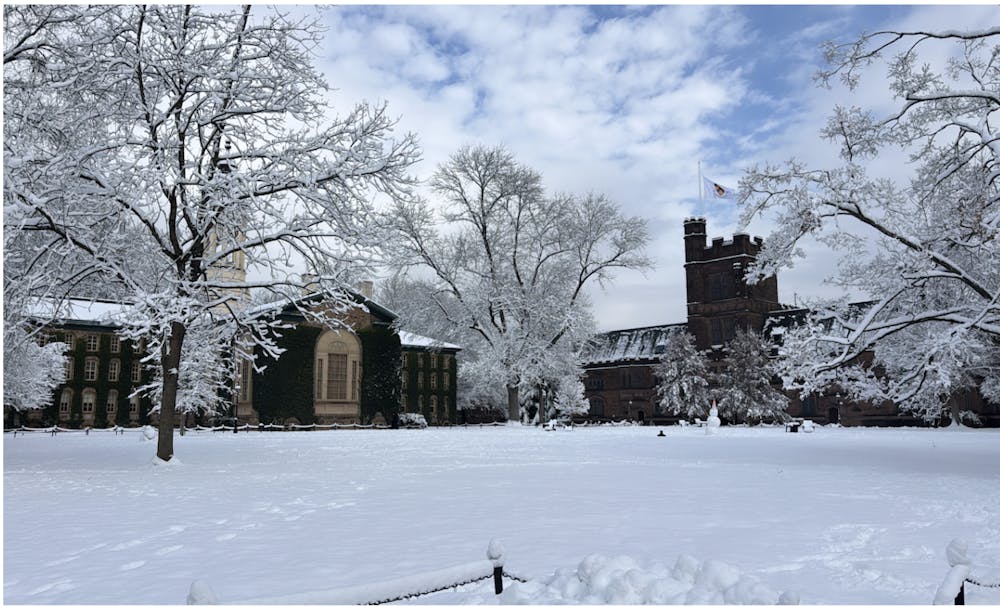
Four weeks after a winter storm brought nearly a foot of snow and widespread travel delays to the Princeton area, another winter nor’easter is expected to sweep through central New Jersey on Sunday and Monday, forecasters say.
The incoming blizzard is expected to bring a mix of heavy snowfall and strong winds. The latest projections from the National Weather Service indicate a high likelihood of one to two feet of snow, though totals remain subject to change as the storm track becomes clearer.
Harsh conditions are expected to make travel “difficult to impossible,” according to the National Weather Service, which has issued a blizzard warning for the Princeton area.
Meteorologists say the storm will likely begin as snowfall on Sunday morning before intensifying midday. Up to 35 mph wind gusts are expected, raising the possibility of blowing snow and reduced visibility on local roads.
In a press release on Saturday afternoon, N.J. Governor Mikie Sherrill announced that the state will enter a “State of Emergency effective at 12:00 p.m. on Sunday, February 22.” This is the second State of Emergency she has issued related to the weather since her term began in late January. According to the release, all regions of the state could be hit with 10 inches of snow or more.
NJ Transit is monitoring the storm and may adjust its services, according to its website. During the previous storm, NJ Transit temporarily suspended nearly all its services.
The Princeton Police Department has urged residents to prepare in advance by moving vehicles off roadways during the storm and limiting nonessential travel during peak snowfall.
Most forecasts earlier in the week predicted a much weaker storm. On Friday, conditions changed as models shifted toward a more severe scenario.

At the time of publication, most meteorologists agreed that the region would face an unprecedented storm. Unlike January’s storm — which had been widely predicted days in advance — this storm intensified more quickly and is expected to bring stronger winds and wetter snowfall.
If snowfall totals reach the higher end of current forecasts, Sunday’s storm could rival or exceed the previous storm’s impact on the Princeton area. However, slight shifts in the storm’s coastal track temperature could change the actual precipitation.
As of Saturday afternoon, the University has yet to announce any closures. The University provides updates to the community regarding campus operations via email and TigerAlert. Weather updates for Central Jersey can be viewed here.
Hayk Yengibaryan is a head News editor emeritus, senior Sports writer, and senior News writer for the ‘Prince.’ He is from Glendale, Calif. and typically covers breaking news and profiles. He can be reached at hy5161[at]princeton.edu.
Please send any corrections to corrections[at]dailyprincetonian.com.
A correction was made on Feb. 21, 2026: A previous version of this article incorrectly spelled Yengibaryan’s name in the image caption. It is Yengibaryan, not Yengibarian. The ‘Prince’ regrets this error.
Read More

NJ AI Hub marks first anniversary with inaugural startup cohort
Zihan (Frank) XuFourteen selected start-ups receive weekly workshops, reverse pitches, corporate introductions, among other guidance over 12 weeks. The “AI accelerator” helps to test each company’s technology and fast-track its path to commercialization.
Fourteen selected start-ups receive weekly workshops, reverse pitches, corporate introductions, among other guidance over 12 weeks. The “AI accelerator” helps to test each company’s technology and fast-track its path to commercialization.
Three Princeton alumni awarded 2026 Fields Medal
Clara DochertyThe three alumni who received the medal are Yu Deng GS ’15, John Pardon ’11, and Jacob Tsimerman GS ’11.
The three alumni who received the medal are Yu Deng GS ’15, John Pardon ’11, and Jacob Tsimerman GS ’11.

How Charles Plohn ’66 brought his classmates together on the shelves
Nikki HanFor decades, Charles J. Plohn, Jr. ’66 has been collecting books published by members of his class. With nearly 700 titles in this collection, Plohn is attempting to find his library a permanent home.
For decades, Charles J. Plohn, Jr. ’66 has been collecting books published by members of his class. With nearly 700 titles in this collection, Plohn is attempting to find his library a permanent home.